
What is open trip planner and why is it an effective Google Maps alternative?

Introduction
Efficient and accessible transit solutions are essential to urban development and sustainability. As a leading transit solutions provider, we've implemented Open Trip Planner (OTP) in the websites of our transit clients providing a better user-experience for commuters. OTP is an open-source platform that utilizes geographic data and advanced algorithms to create customizable, user-friendly trip planners that align with each client's requirements and their style guide.
This insight post explores the core technical components of OTP, its workflow, and why it's a preferred choice over commercial solutions like Google Maps.
Trip Planners
A trip planner helps users navigate transit systems by determining shortest routes, estimating travel time, suggesting modes of transport, providing real time updates guiding users from starting location to destination provided. In addition to the regular functionalities, a customized trip planner is a cutting edge solution that can provide a branded user-experience.
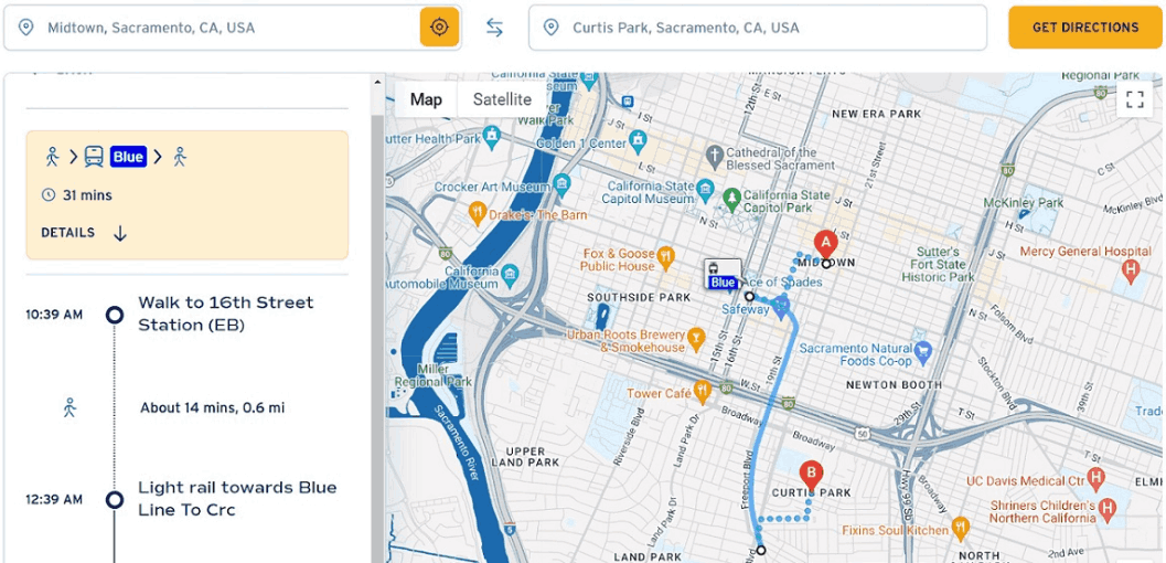
Custom trip planner widget that we built for one of our transit clients Sacramento Regional Transit:
GTFS: The Backbone of Transit Data
General Transit Feed Specification (GTFS) is a standardized data format containing specific data about the transit system in multiple text files. Below are a few of the key data files that GTFS provides.
- Stops: Locations where transit services are available.
- Routes: Paths that transit vehicles follow.
- Trips: Scheduled trips along routes.
- Stop Times: Timing for each stop on a route.
Example Snippet: stops.txt:
<script src="https://gist.github.com/Ashwin2kPower/8fb43143b7b7f7d95dc329bce855241a.js"></script>
GIS Software for Geographic Data
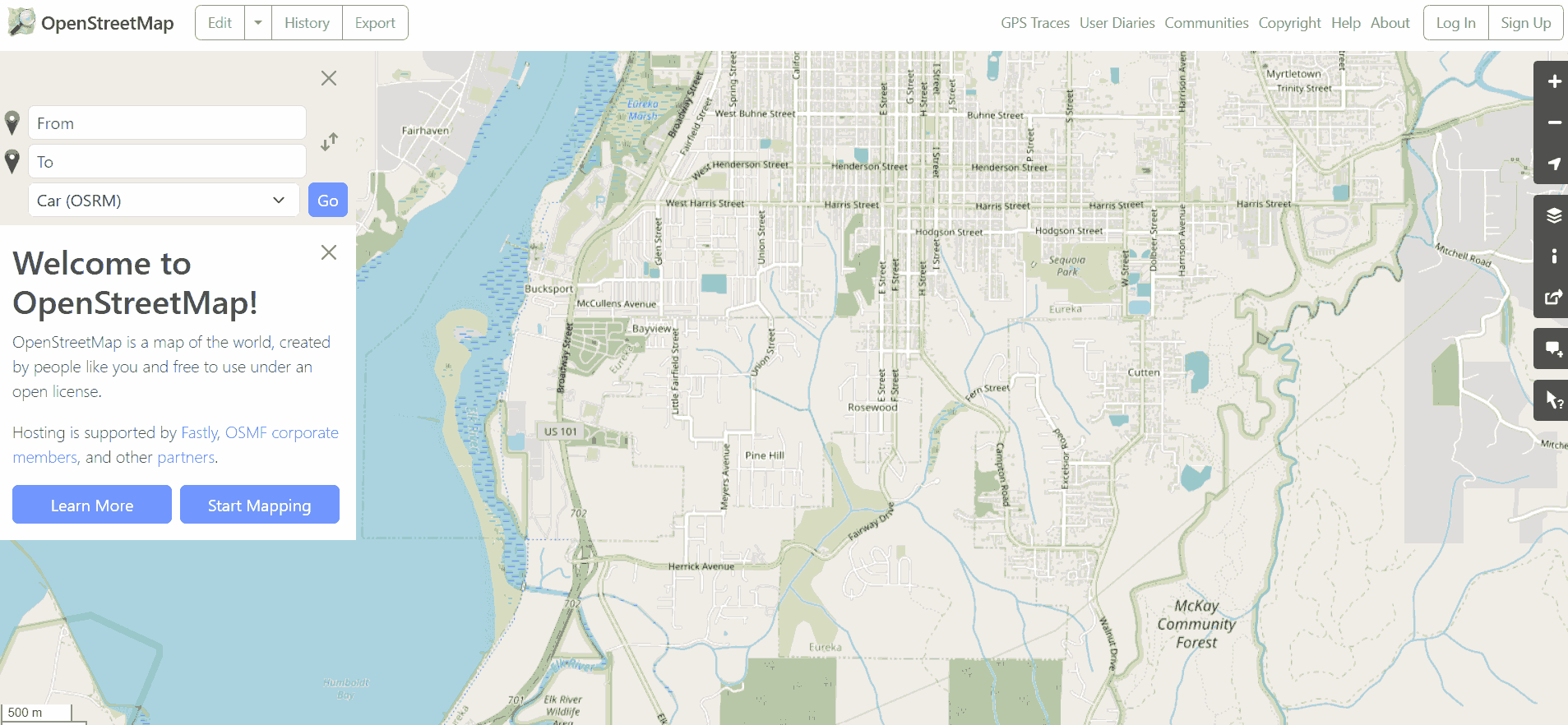
Geographic Information Systems (GIS) tools like ArcGIS, QGIS and Open Street Maps (OSM) are used for visualization of geographic features and relationship between them, mapping, route-planning and spatial analysis of geographic data provided enhancing the trip planners with better accuracy and realism of routes.
Pathfinding Algorithms
Pathfinding algorithms are computational methods used for finding the shortest path from the starting point to the destination. Following the GTFS data and GIS integration, pathfinding algorithms are utilized. Below are some of the significant pathfinding algorithms that exist:
- Dijkstra’s Algorithm: Finds the shortest path between nodes in a graph.
- A (A-Star) Algorithm*: An extension of Dijkstra’s, optimized for efficiency.
- Contraction Hierarchies: Speeds up route queries by creating shortcuts.
Dijkstra's Algorithm Example
<script src="https://gist.github.com/Ashwin2kPower/5837948ca168d9ea2eb70b8183f3af0b.js"></script>
Dijkstra's Algorithm visualization

GeoJSON and TopoJSON
GeoJSON and TopoJSON are JSON based data formats for encoding geographic data like points, lines and polygons and are used for efficient and clear visualization of geographic data in OTP.
GeoJSON Example:
<script src="https://gist.github.com/Ashwin2kPower/c09e6b3f5de2835d03094a3ee979ff87.js"></script>
Workflow of Open Trip Planner
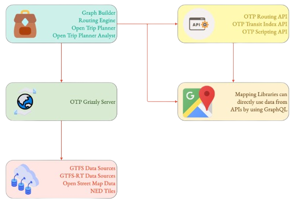
- GTFS Data Import: Collect and validate GTFS data to build the transit network.
- GIS/OpenStreetMap Integration: Integrate geographic data for detailed context.
- Trip Query: Users input their travel preferences, and OTP processes these queries.
- Pathfinding Algorithms: OTP calculates the optimal routes using selected algorithms.
- GeoJSON/TopoJSON Output: Routes are encoded and displayed on an interactive map.
Open Trip Planner as a Google Maps Alternative

OTP offers a customizable, open-source alternative to Google Maps with distinct advantages:
- Customization and Flexibility: Tailored routing options and integration with custom data sources.
- Control Over Data: Organizations retain full control over their data, crucial for privacy.
- Cost-Effectiveness: Eliminates licensing fees, making it a scalable solution.
- Enhanced Multimodal Support: Robust support for multimodal trip planning, including bike-sharing and ferries.
- Integration with Existing Infrastructure: Seamless integration with GIS software and websites or mobile apps.
These features make OTP an attractive option for organizations seeking a comprehensive and personalized transit planning tool, without relying on the limitations of commercial platforms like Google Maps.
Conclusion
By leveraging GTFS data, GIS integration, and advanced pathfinding algorithms, Open Trip Planner (OTP) can provide efficient and user-friendly trip-planning experiences. Whether you're a city planner, a transit agency, or a developer, OTP offers a flexible and scalable solution for building the powerful next generation of transit solutions.
If you would like to learn more about OTP and how it can help with your transit needs drop us a mail and join us on LinkedIn, Facebook and X.